
Multiscale project
MULTI-variate, -temporal, -resolution and -SourCe remote sensing image Analysis and LEarning
Funded by ANR (France) and Tubitak agency (Turkey)
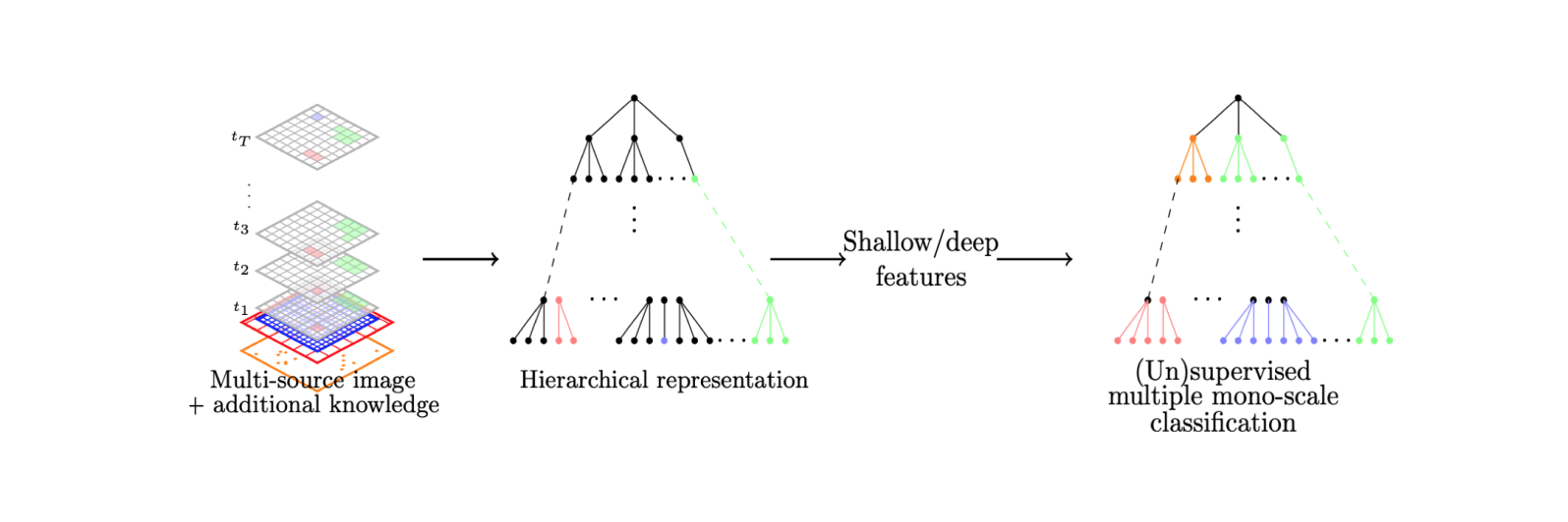
MULTISCALE is a research project that aims at providing a complete and integrated framework for multiscale image analysis and learning with hierarchical representations of complex remote sensing images. While hierarchical representations of RS images has led to an effective and efficient scheme to deal with panchromatic or at most multiband data, their application to complex data is still to be explored. In addition, despite their ability to encode structural and multiscale information, their so far exploitation have not reached beyond a mere superposition of monoscale analysis. In this context, the MULTISCALE project defines new methods for the construction of hierarchical image representations from multivariate, multi-source, multi-resolution and multi-temporal data, and provides some dedicated image analysis and machine learning tools to perform multiscale analysis. The new methodology will be implemented in various toolboxes used by the community to favor the dissemination of the results. Success of the project will be assessed by benchmarking the proposed framework on two remote sensing applications. Substantial breakthroughs over classical methods are expected, both in terms of efficiency and effectiveness.
Objectives of the project
The MULTISCALE methodological objective is to propose new methods for the construction of one or more hierarchical image representations from multivariate, multi-source, multi-resolution and multitemporal data. These representations can then been exploited in order to perform feature extraction or to directly conduct multiscale learning of a region of interest. We intend additionally to explore the integration of a priori knowledge into the tree construction and description stages, when available (e.g. from ground truth or ontologies), with the end of better directing the underlying processes and thus improving the final results. In short, this project aims to provide a methodological foundation capable of adapting automatically to a given theme and region of interest requiring a multiscale analysis. In more detail, the project methodological objectives can be summarized as follows:
Publications
Here is a list of the publications associated to the ANR part of the project (see the list in HAL with Analyse d'image et apprentissage pour des données de télédétection multi-variées, -temporelles, -résolution et -source MULTISCALE - ANR-18-CE23-0022)
International conferences
- Mahey, G., Chapel, L., Gasso, G., Bonet, C., & Courty, N. Fast Optimal Transport through Sliced Generalized Wasserstein Geodesics. Conference on Neural Information Processing Systems (2023)
- Hamzaoui, M., Chapel, L., Pham, M. T., & Lefèvre, S. Hyperbolic Variational Auto-Encoder for Remote Sensing Embeddings. International Geoscience and Remote Sensing Symposium (2023)
- Hamzaoui, M., Chapel, L., Pham, M. T., & Lefèvre, S. A Hierarchical Prototypical Network for Few-Shot Remote Sensing Scene Classification. International Conference on Pattern Recognition and Artificial Intelligence (2022). (best paper award)
- Chapel, L., Flamary, R., Wu, H., Févotte, C., & Gasso, G. Unbalanced optimal transport through non-negative penalized linear regression. Advances in Neural Information Processing Systems (2021).
- Mirmahboub, B., Moré, J., Youssefi, D., Giros, A., Merciol, F., & Lefèvre, S. Fast pattern spectra using tree representation of the image for patch retrieval. International Conference on Discrete Geometry and Mathematical Morphology (2021)
- Santana Maia, D., Pham, M. T., & Lefèvre, S. Watershed-based attribute profiles for pixel classification of remote sensing data. International Conference on Discrete Geometry and Mathematical Morphology (2021)
- Chapel, L., Alaya, M. Z., & Gasso, G. Partial optimal transport with applications on positive-unlabeled learning. Neural Information Processing Systems (2020)
- Guiotte, F., Etaix, G., Lefèvre, S., & Corpetti, T. Interactive Digital Terrain Model Analysis in Attribute Space. ISPRS International Congress - International Archives of the Photogrammetry, Remote Sensing and Spatial Information Sciences (2020)
- Merciol, F., Pham, M.T., Santana Maia, D., Masse, A., & Sannier, C. BROCELIANDE: a comparative study of attribute profiles and feature profiles from different attributes. ISPRS International Congress - International Archives of the Photogrammetry, Remote Sensing and Spatial Information Sciences (2020)
- Tuna, C., Giros, A., Merciol, F., & Lefèvre, S. On Morphological Hierarchies for Image Sequences. IEEE International Conference on Pattern Recognition (2020)
- Tuna, C., Merciol, F., & Lefèvre, S. Spatio-temporal object stability for monitoring evolving areas in satellite image time series. ISPRS International Congress - International Archives of the Photogrammetry, Remote Sensing and Spatial Information Sciences (2020)
- Guiotte F., Lefèvre, S., & Corpetti, T. Attribute filtering of urban point clouds using max-tree on voxel data. International Symposium on Mathematical Morphology (2019)
- Guiotte F., Lefèvre, S., & Corpetti, T. Voxel-based attribute profiles on lidar data for land cover mapping. IEEE International Geoscience And Remote Sensing Symposium (2019)
- Guiotte F., Lefèvre, S., & Corpetti, T. Rasterization strategies for airborne LiDAR classification using attribute profiles. IEEE/ISPRS Joint Urban Remote Sensing Event (2019)
- Tuna, C., Merciol, F., & Lefèvre, S. Spatio-temporal object stability for monitoring evolving areas in satellite image time series. International Workshop on the Analysis of Multitemporal Remote Sensing Images (2019)
- Tuna, C., Merciol, F., & Lefèvre, S. Attribute profiles for satellite image time series. IEEE International Geoscience And Remote Sensing Symposium (2019)
- Tuna, C., Merciol, F., & Lefèvre, S. Monitoring urban growth with spatial filtering of satellite image time series. IEEE/ISPRS Joint Urban Remote Sensing Event (2019)
International journals
- Hamzaoui, M., Chapel, L., Pham, M. T., & Lefèvre, S. Hyperbolic prototypical network for few shot remote sensing scene classification. Pattern Recognition Letters, 177, 151-156 (2024).
- Alvarez-Vahnhard, E. , Fernandez Garcia, G., & Corpetti, T. Super-resolution by fusing multi-spectral and terrain models: application to water level mapping. IEEE Geoscience and Remote Sensing Letters (2023)
- Santana Maia, D., Pham, M. T., & Lefèvre, S. Watershed-based attribute profiles with semantic prior knowledge for remote sensing image analysis. IEEE Journal of Selected Topics in Applied Earth Observations and Remote Sensing, 15, 2574-2591 (2022)
- Mirmahboub, B., Santana Maia, D., Merciol, F., & Lefèvre, S. Median-Tree: An Efficient Counterpart of Tree-of-Shapes. Mathematical Morphology - Theory and Applications, 5(1), 108-127 (2021)
- Santana Maia, D., Pham, M. T., Aptoula, E., Guiotte, F., & Lefèvre, S. Classification of remote sensing data with morphological attribute profiles: A decade of advances. IEEE Geoscience and Remote Sensing Magazine, 9(3), 43-71 (2021)
- Tuna, C., Mirmahboub, B., Merciol, F., & Lefèvre, S. Component trees for image sequences and streams. Pattern Recognition Letters, 129, 255-262.
Consortium
- Equipe Obelix, IRISA, univ. Bretagne Sud
- LETG, univ. Rennes 2
- Gebze Technical University
- Istanbul Technical University


Contacts
Please send all comments and questions on this project to Laetitia Chapel and Erchan Aptoula